I emigrated here from England in 1968. When I first arrived, I wasn't sure that I was going to like it. They were still using trolley buses in those days, and the streets looked very junky with the wires criss crossing overhead, and many streetcar tracks were still in the roads. To me, the place looked very dingy and outdated.
However, it seemed like a fast growing city, and the council of the day were keen to make changes. In no time, the trolley buses were gone, the streets were repaved, and there was construction going on everywhere. Shopping centres were springing up in every suburb.
My first husband and I bought a house in Transcona, which seemed at the time to be a long way from the city itself. When driving out from downtown, there was nothing except the Starlight drive-in theatre once you got past the old highway 59, until you came to the shops of Transcona itself. Now, Transcona is a thriving community, with so many big name stores in what used to be empty fields, that the residents have no need to ever leave the area.
Many years ago, before the age of photographs, the area at the forks of The Red and Assiniboine Rivers was used as a meeting place and trading post. When I came here, that area was being used by the Canadian National Railway as yards.
The city, with help from the Federal and Provincial governments, undertook the huge project of turning The Forks, as it was subsequently called, back into a meeting and gathering place. This has become a great success, and many events are held there each year. We also have The Forks Market - produce stalls etc. in the traditional sense, and many interesting little boutiques.
There are boat rides from here in the summer, and skating in the winter. Good restaurants and lots to do makes it the perfect place to meet up with friends. (I don't work for The Forks, or The City of Wpg. - honest!) :-)
You will find old pictures of Winnipeg here, and a link at the bottom of the page to go to the more up to date ones. So here we go!
|
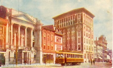
These pictures are not in any kind of chronological order, because I don't know when most of them were taken. However, I do know that this one was snapped in 1908, and was classified as The Banking District. I am not sure where it was located, but by the width of the street, I would guess Main Street.
|
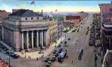
Still on a banking theme, this is The Bank of Montreal on the corner of Portage and Main. The building is still there, but somehow doesn't look quite so majestic now it is surrounded by so many other large buildings.
|
This is The Auditorium, which was the predecessor of the Concert Hall. It was built in 1932 as a depression make work project. The Provincial Archives were relocated here in 1974 from their premises in the Legislative building, and are still there, along with the Hudson's Bay Company archives. The building is on the corner of St. Mary Avenue and Memorial Blvd. You can see the Legislative Building in the background, and Osborne Street curving off to the right.
Just look at those wide open spaces - they are certainly not still there!
|
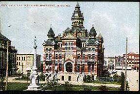
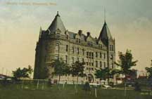
This was City Hall and Monument. What a lovely building! What were they thinking of to pull it down? Or was it yet another building that burned down? I guess the monument went along with it, because I don't remember seeing it.
Just heard from Brad Froggatt in the guestbook that the monument was moved to the plaza at the Centennial Centre and is still there. The times I have been there, and have never noticed it! I noticed the statue of the Queen, but not the monument.
|
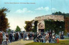
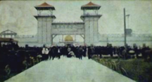
This was Fort Garry Gate, all that was left of the Upper Fort Garry building. Sadly there was even less than that by the time I arrived in 1968, then, after the new Norwood Bridge was built, the gate is so sandwiched between modern buildings that you can barely see it any more!
|
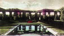
Isn't this lovely? It was known as the lily pond in City Park. Now it is known as The Tavern in the Park, and City Park is known as Assiniboine Park.
As much as I like the restaurant, I think we lost something here don't you?
|
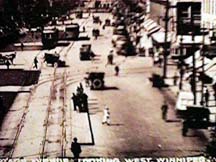
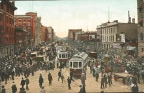
This view of Main Street doesn't look all that old. I wonder why there is a conglomeration of vehicles on one side of the street, and absolutely none on the other?
Peter Stewart-Hay took me to task over this one, asked why it didn't occur to me that the traffic we can see was waiting for the lights to change, and the north bound traffic was sitting at the lights out of sight!
Call it a blonde moment Peter! :-)
|
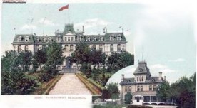
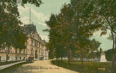
Now this one is pretty old! This is the way the Legislative building used to look. Inset is the Governor's mansion.
|

This shows Portage Avenue again - even older by the looks of it. I see they did have something to stand on in the middle of one section.
See the streetcar tracks too? Interesting that they are only on one side of the street, I wonder what they did when they wanted to go the other way?
|


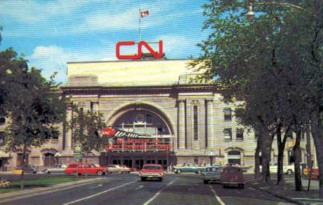
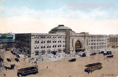
The CN station at the junction of Main and Broadway. Still much the same, except it now has a Via sign instead of CN. Looks as if this photo was taken in the mid 60's when gas was cheap enough to run those big cars!
|

Deer Lodge hospital. I have no idea where it was located when it looked like this. Maybe someone can tell me? See the picture at the bottom of this page as it looks today - what a difference!
|
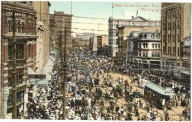
This was Main Street on Labour Day, 1915. What on earth were they all doing there? These days, we all head to the lake!
|
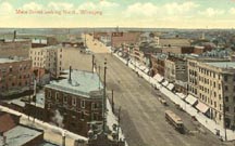
Another one of Main Street, a couple of years earlier, and certainly not as much going on!
|

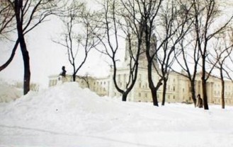
Some things never change! The snow keeps arriving every year, just as it always has!
Here you see the Legislature partially hidden behind a snowbank
|
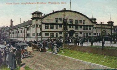
This is a picture of a horse show, held at the Amphitheatre located at Whitehall & Colony. Built in 1909, it also served as a theatre for stars such as Sarah Bernhardt and Nelson Eddy. It also hosted circuses, skating carnivals, championship hockey and many other attractions. It closed in 1955, and was later demolished to make way for the Great West Life building.
|

This was the Canadian Northern Railway exhibit at the Winnipeg Permanent Exposition in 1912.
I would love to know about this Exposition too, does anyone know anything about it? Where it was housed etc.?
|
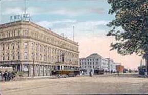
This photo is a little fuzzy, but it is the only one I have managed to find so far of the Empire Hotel on Main Street, now sadly no longer there. You can also see the Union Station in the background. Don't you love the streetcar? :-)
|
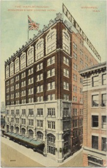
While we are on a roll with hotels, this one is The Marleborough. Note they are flying the Union Jack.
|
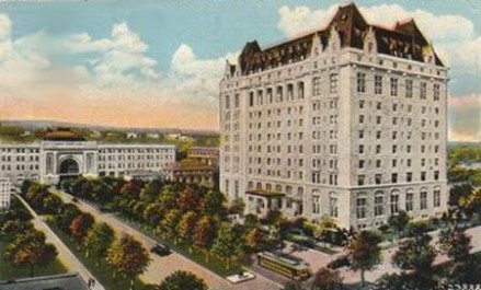
and The Fort Garry, which of course is still there in all its glory.
|
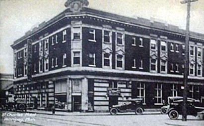
and a very old one of the St. Charles
|
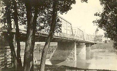
Here we have a tinted photo of the Maryland Bridge This is not the way it looked originally though, because as you can see in this photo on the right, sent to me by Rob McInnes, it once had an overhead structure, as did many of the bridges in the city.
|

and a badly tinted one of the CPR Station
|
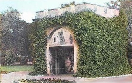
This picture of the Fort Garry gate must be a little more recent than the one above, because the foliage has grown a little higher!
|
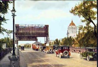
This picture is fascinating of the Osborne Street bridge. I love the old cars and the streetcar, but what the heck are those big things straddling the road for?
|
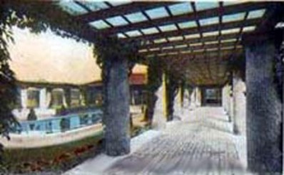
Another picture of the lily pond in Assiniboine Park, but this time featuring more of the pergola
|
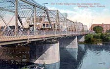
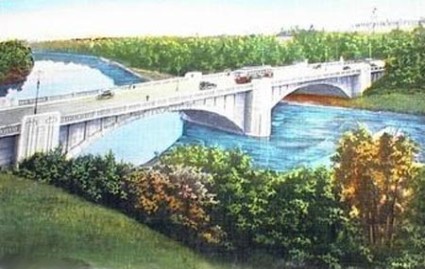
This bridge was called 'The Traffic Bridge' over the Assiniboine River. Does anyone know if it is still there today, and what it is now called?(sorry it's so fuzzy)
|
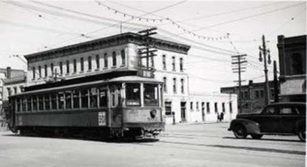
Here is a lovely clear picture of a streetcar
|
This building is still there It is the Union Station, now known as the Via Rail station.
|
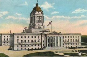
A colour tinted picture of the Legislature
|
The famous Portage & Main corner, and hey look! You could cross the street there back then!! (further explanation of this on the Winnipeg Now page, linked below )
|
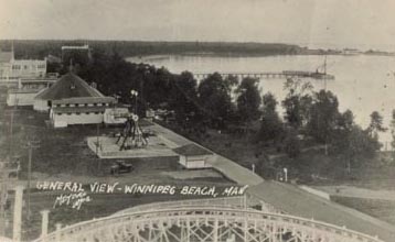
This is where everybody went to have a good time in the old days. Winnipeg Beach. You could catch a train from Winnipeg, and have a weekend of fun! See the rollercoaster in the foreground?
|
Would you like to see more old photos of Winnipeg? If so, click here for page two, but if you would like to see how Winnipeg looks today, click on the link below. Or check out my other home town, Folkestone in Kent, England.
|
Come back often, because I will add to these pages every time I get some more material.
|
Updated March 7, 2009
|
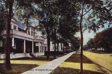
How Assiniboine Avenue looked in 1910
|
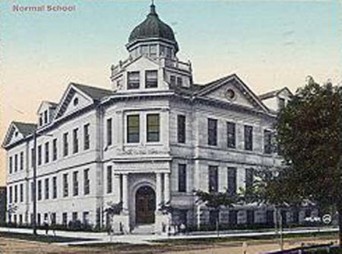
This is also 1910, and is called Normal School, I wonder if they also had Abnormal School too? No, surely not!
I believe this building is still standing, and is now apartments, but I could be wrong.
|
Another view of a busy Portage Avenue. Less cars, and more pedestrians in those days. I bet there was less obesity in those days too!
|
The Hudson Bay Company on Portage & Memorial in the 1940's
|
Another one of the lovely old City Hall building
|
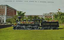
A 1933 picture of The Countess of Dufferin. Which I think used to be on display opposite the CPR station - but again, I stand to be corrected.
|
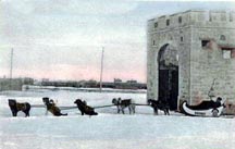
The Fort Garry gate in winter, shown here with a dog train alongside.
|
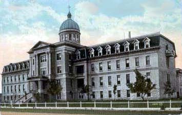
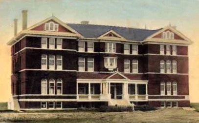
Winnipeg General Hospital was established in 1873. Originally a wooden building, replaced by a larger brick building in 1883. This is how the centre sections looked in 1910. The land it stands on was donated by Andrew McDermot and his son-in-law A.G.B. Bannatyne. Both wealthy businessmen. The hospital is now known as the Health Sciences Centre, and looks very different to this!
|
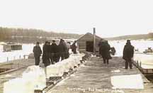
Ah yes, we haven't always had freezers you know! This is ice cutting on the Red River, and I am sure it was a very lucrative business for some.
|
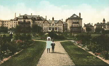
The Misericordia Hospital has undergone many changes too. It was started by four sisters of Misericordia, who opened a mission in 1898 to care for "abandoned & forlorn children". It progressed to a maternity hospital in 1903, when it looked about half this size, then the centre section and the other half was added, and it became a general hospital in 1916.
|
Another view of the Legislature, showing a nice old car parked outside.
|
This is how the Pavilion in Assiniboine Park used to look from 1909 to May 27, 1929 when it burned down. However, it was then known as City Park. I would love one of those old cars.
|
These were entitled The Post Office and Free Press Buildings. But didn't say where they were located. Possibly Portage & Carlton?
|
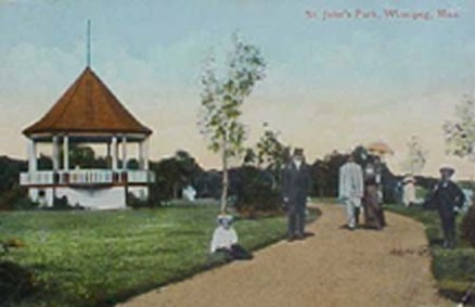
St John's Park, where, in 1909 there used to be a little walk called 'Lovers' Lane'. I think this park is long gone now, isn't it? Where was it? Anybody know?
|
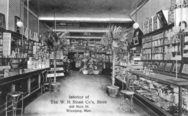
Let's go shopping! This was the interior ot W. H. Stone Co.'s store at 648 Main Street. Don't you love the palms? I especially like the elegant chairs, put there so customers could shop in comfort. They should take care of us that well now! I bet they didn't have to bag their own, and pay for the bag to boot either! The inside of this store is so fascinating, if you click on the picture, you will see a closer version of it.
|
This photo is when this building was Wesley College, between 1896 and 1938. It then became United College until 1967, when it became the University of Winnipeg.
I didn't realise when I arrived here in 1968, that the U of W had only existed one year.
|
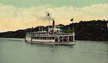
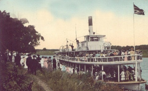
This is the only way to travel on the Red River! (Or was it on the Assiniboine River?) This steamboat was called The Alberta.
|
This one was entitled 'New Dips, Winnipeg Beach.
|
Home
|
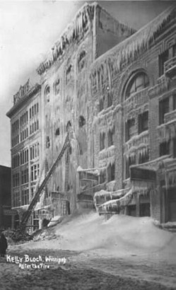
This is how it looks when we have a fire in winter! This unfortunate building was known as The Kelly Block, the year was 1911, and the temperature was -42ºF !
|

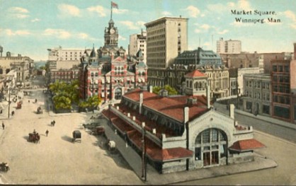
I am very curious about this building. I have searched the net, and all the books I have, but can find absolutely no information about it. You can clearly see City Hall in the background, so I am wondering if the building in the foreground is the reason why the area is called Market Square. Was it perhaps an indoor market? If anyone can tell me, I would be very grateful.
|
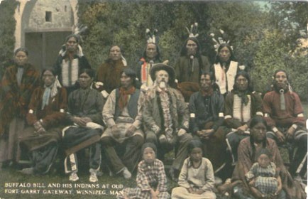
Here is a strange photograph. It is entitled 'Buffalo Bill and his Indians at Old Fort Garry Gateway, Winnipeg'
I am assuming he had a travelling show, and was performing in Winnipeg at the time.
|
I have received a long message in my guestbook from Bob, now in Toronto, who has put me straight on a lot of things. One being that these tracks are in fact in the centre of the road, and do indeed go both ways! When I look more closely, I can see he is absolutely right.
|
Bob tells me that this building was located in Deer Lodge, Manitoba, which was approximately the same location of the present Deer Lodge Veteran's hospital, but it is now part of Winnipeg.
|
Bob thinks that they were the mechanism to lift and swing the bridge. I wasn't aware that that particular bridge ever opened. He also told me that the Osborne bridge formed part of what was called "The crosstown highway" which was made up of Salter which changes its name to Isabel, which changes its name to Balmoral, which changes to Osborne.
|
Bob suggests that this one is a CNR or CPR bridge (shared by streetcars) near Omand's Creek, and crosses over to Wellington Crescent. Which makes sense, because the traffic going over the underpass on Portage Avenue would have to cross the Assiniboine south of Portage
Someone else suggested it might be the Louise Bridge, but I am still not 100% certain.
|
Bob, and my husband, (also a Canadian) tell me that teacher training colleges are always called Normal Schools. How very strange!
|
Yes indeed, I was correct on this one. Apparently every Christmas it would be decorated with lights, and the wheels would flash on and off in sequence giving the illusion they were going round and round.
|
Apparently, it is still there - and you are looking at just about all of it! It's on the east side of Main Street at Mountain or St. John's Avenue.
|
Yes, now I know! It was called the Farmer's Market, and was located on the present day site of the Public Safety Building.
According to Brent, it too was a casualty of the 'Modern' Winnipeg - i.e. Centennial Centre buildings (Concert Hall, Museum and Planetarium, City Hall, Public Safety Building)
|
Bob tells me Buffalo Bill Cody had a famous travelling rodeo, and that one of his stars was Annie Oakley, the lady who was a little too handy with a gun to upset!
|
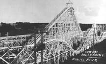
Bob tells me the rollercoaster was made of wood.
|
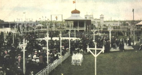
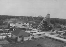
And here is an amusement park that was probably put out of business by the success of Winnipeg Beach. It was called Happyland, and was located on about 13 hectares of land between Aubrey and Dominion Streets from Portage Avenue south to the Assiniboine River. It was opened on May 24, 1906. (Thanks Wendy Tapping for that bit of information!) This picture of the entrance was taken in 1908. It came down around 1922, but was in financial trouble long before then.
|
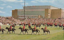
Musical Ride 1967
|
There are lots of pictures to load, so please have patience. If some of the pictures do not appear, right click your mouse into the blank space, and click 'Show Picture", and it should come in for you.
|
This roller coaster wasn't dismantled until at least the 60's, although it hadn't been used for many years prior to that.
|
I wonder how many of you will guess which hospital this is in 1913? It looks very different today.
The hospital which now employs my stepdaughter as a pharmacist is The Grace. Once a Salvation Army hospital located on Booth Drive, does anyone know if it was in the same location in 1913?
|
The picture above was entitled 'River Park Roller Coaster'. Was River Park the same one as Happyland, or was this yet another amusement park?
|
Someone certainly does know! I just had a message in my guestbook from Sandra in Saskatchewan who tells me that the Salvation Army once ran this building as a home for unwed mothers, and it was located (and still is) on Arlington Street. The building was erected in 1906, and later became The Grace Hospital. Thanks Sandra!
|
Aha! I just knew someone would be able to answer this question, and sure enough, here is the answer as posted in the guestbook by Grant Moore:
"I noticed you were wondering about the difference between Happyland and River Park. River Park was actually located on South Osborne near Riverview, along the Red River in what is now Churchill Park, Churchill Drive, and the newer housing that has since been built there. Across the river, where Kingston Row is now, was Elm Park which was a more natural picnic area and, interestingly enough, privately owned (visitors paid a toll)."
|
How interesting! So now we know. Thanks Grant!
|
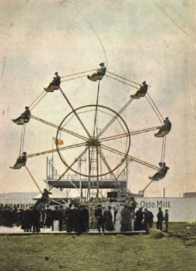
Happyland
|
Riding the ferris wheel at Happyland
|
This one was entitled 'Alberta at Riverside Park' which brings me to another question. Was River Park and Riverside Park the same place?
|
Wendy has a wonderful collection of photographs herself, handed down from her Grandfather, Alexander Ross McPherson, who used to own City Creamery, which was later sold and became Modern Dairies, Crescentwood Dairies, and then Silverwood Dairies. Her collection also includes some amazing photos of the Winnipeg flood in 1950. Click HERE to see them.
|
Buffalo Bill travelled all over the world. Here is a report from 1903 in the Manchester Guardian where they stopped first when visiting Britain. Note the prejudice in the last paragraph! Normal for the time, but quite disturbing by today's standards.
|
Bob in Toronto tells me that the facade of this hotel was made of iron, and parts of it were preserved when the hotel was demolished. The provincial government has a page showing how they have it now.
|
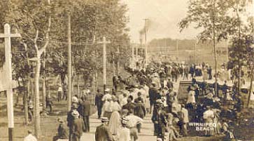
We will finish off this page out at Winnipeg Beach, where you can see the crowds flocking towards the train in the distance. There was a regular service from Winnipeg, and was never short of passengers.
|

Brent Driedger of Winnipeg wrote to say that this City Hall was built by Barber and Barber Architects in 1886 was demolished in 1964 at the hands of the city's politicians of the day to make way for what they envisioned as the new Modern Winnipeg. Shame on them I say!
|
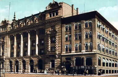
This is a card that has caused a lot of discussion, because the title on it clearly says it is Portage Avenue, but we are going with the majority, and will say it is wrong! It is definitely Main Street, because the Union Bank - which is now the Royal Bank building is clearly in the background.
Thanks to everyone who took a vote on it. The best men & women won!:-)
|
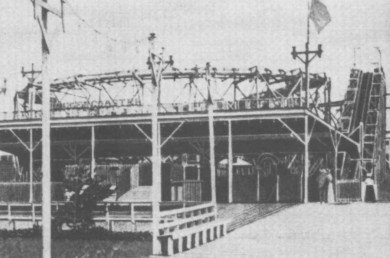
Here we have the roller coaster at Happyland Park, taken in 1910.
If you are a roller coaster enthusiast, there is a very good Canadian website devoted to them!
It is run by Richard, and you can find it here Coaster Enthusiasts of Canada
|
The following web pages have prompted many former and current Winnipeggers to write to me. Letting me know the answers to some of the questions I have posed next to the photos, or filling me in on a little more of the history behind them. Others have written with their childhood memories of what it was like to grow up in Winnipeg, and have given me a little more insight into the way it was before I arrived.
I find all of your letters so interesting (even the critical ones), that I have decided to have a special guestbook devoted to your memories of Winnipeg. I have moved the letters which were previously on the Winnipeg Memories page to this guestbook, and if you have written to me recently, you will probably find your letter there too. If you object to this, or notice any errors, please let me know. Now you can post your Winnipeg thoughts directly into the book, so if you have an urge to correct me on something, check there first, as someone might have beaten you to it!
|
Ron Tomasson wrote to say he thought this was between Bannatyne and McDermot, and is now a dance studio next to the Woodbine Hotel, the oldest in western Canada.
|
Someone else has a different view though - check in the Guestbook.
|
If you would like to go directly to the Guestbook, click here:
|
Here is an absolute treat for you: I have been allowed to scan a very rare book of Winnipeg photographs to add to this website. I am absolutely thrilled to show them to you. Click here to see the JOHN STEEL COLLECTION
|
If you have your own memories of Winnipeg, please share them with us by jotting them down in the book above
|
To check your bearings, (and to find my mistakes!) you might find this 1911 map of Winnipeg useful.
Use your back button to come back here afterwards
|
Peter Stewart-Hay also wrote about this picture:
The picture shows the counterweights that were removed and destroyed when the bridge lifting action was decommissioned many years before (Date unknown.) the bridge was actually replaced. Some of the mechanism was saved as a memorial and mounted on the south -west side of Osborne Street by the new bridge when that new bridge was opened. The problem as I understand it was that the contractor with the blessing of the city filled the concrete arch sections of the old bridge with fly ash and clinkers possibly from the old steam heating plants downtown and in Old River Heights. This ash was acidic and rotted the concrete necessitating bridge replacement.
|
Bob wrote again about this bridge, he now has a new theory:I am now pretty certain that the Traffic Bridge postcard is the original Norwood Bridge (connecting Main St. & St. Marys). this would be a looking north view. Someone suggested that the building on the right is the Hudson Bays office building. Also, if you look carefully through the bridge structure, you can see the Hotel Fort Garry under construction. This theory is backed up by Chris Jones, who writes: The "Traffic Bridge" is definitely the Main Street Bridge, looking north from Fort Rouge. You can tell because Hudson Bay House (now Gibraltar House) and the Fort Garry Hotel are in the background.
The bridge was built over 100 years ago. It was replaced in 1931 by a concrete bridge, which in turn was replaced in 1995 by the present bridge.
|
David Jenkins wrote about these:
These buildings are both gone, but were on the south side of Portage Avenue between Fort and Garry Sts. The Free Press Building (pre-Carlton St
building) is the 4 story building on the right at the corner of Portage Ave
and Garry St.
Thanks David, I appreciate the info.
|
Chris Jones also wrote about this hospital: The Grace Hospital I know- my mother was born there in 1938! It was expanded many, many times since the post card picture was taken. Even as late as the 1950's, a giant wing was added on Evanson Street. The Grace moved to Booth Drive in Woodhaven in 1967. The central sections (including the one pictured) of the old hospital, which I remember from living nearby, were demolished in 1974. The 1950's wing, with attached powerhouse, remains as Manitoba Health Dept. offices. The nurses' residence is now apartments, and the extended care building is now a sort of residence for people with mental issues
|
John from Buderim, Qld. Australia wrote to say that from this location, it moved across Higgins near Ross House, then later to Main & Disraeli, then into storage before ending up at the rail museum at the Via station.
|
Chris Jones and John in Australia both confirmed this location. Thanks to both of you too.
|
Chris Jones wrote to say that this building has been fully restored and looks just the way it does here. However, it is not apartments, it is now a Portuguese cultural centre.
|
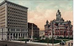
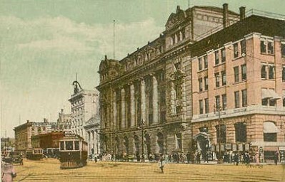
Union Bank on the left and the very majestic City Hall on the right
I have just noticed on a modern map that there is a recreational area just off McPhillips between Jarvis, Sinclair and Flora that is entitled 'Old Exhibition Arena', and 'Old Exhibition Grounds' I wonder if this is where the Exposition was housed?
Found this information in my guestbook from Archie Hay
One of the counterweights on the old Osborne St. bridge actually fell down, fortunately in the middle of the night. I believe the year was 1937. It disrupted traffic and forced the alteration of streetcar routes. During this time a conductor apparently forgot about one alteration and barreled through the intersection of Corydon and Stafford, flipping the streetcar on its side when he discovered the tracks were in a turn mode.
UPDATE: I have just had some more wonderful photos sent to me by Sheila McBeath - so many, and so fascinating I thought they should have a page of their own. I urge you to check them out, they are of some of Winnipeg's most dramatic days! THE SHEILA McBEATH COLLECTION
This from Walter McKechnie: The Osborne Stadium was north of this building and is where the Winnipeg Blue Bombers used to play their games--also the Winnipeg baseball team.
Val Sangster wrote to say she thought it was once called the Aronovitch and Leipsic Building.
Donna Cross wrote: The Auditorium (now the Manitoba Archives) also was a roller skating rink in the 1940's. It had a beautiful hardwood floor, and there was always a line-up to get skates on a Saturday afternoon